It is an honor for me to speak at the Jawahar Bhawan, dedicated to the iconic man, I did not see him but whatever that I read about him, through his writings, has made an everlasting impression on me. I would like to quote Jawahar Lal Nehru from his ‘Will’.
Nehru says,
‘My desire to have a handful of my ashes thrown into the Ganga at Allahabad has no religious significance, so far as I am concerned. I have no religious sentiment in the matter. I have been attached to the Ganga and Januna [Jumna] Rivers in Allahabad ever since my childhood and, as I have grown older, this attachment has also grown. I have watched their varying moods as the seasons changed, and have often thought of the history and myth and tradition and song and story that have become attached to them through the long ages and become part of their flowing waters. The Ganga, especially, is the river of India, beloved by her people, round which are intertwined her racial memories, her hopes and fears, her songs of triumph, her victories and her defeats. She has been a symbol of India’s age‐long culture and civilizatiton, ever changing, ever flowing, and yet ever the same Ganga. She reminds me of the snow‐covered peaks and the deep valleys of the Himalayas, which I have loved so much, and of the rich and vast plains below, where my life and work have been cast’.
My cultural association with Ganga
I was born in a place which is the confluence of two small rivers, tributaries of the Ganga (Ganges), and from where river Kho, begins its journey which is a tributary of Ram Ganga river. The first time I saw Ganga at Muni-ki-Reti and Lakshman Jhula near Rishikesh was when I was just a seven year-old child. The first sight of the Ganga mesmerised me. Then I realised how the Ganga is part and parcel of life of people in Uttarakhand.

I was perplexed to see that movement to protect Ganga did not get any public sympathy in Uttarakhand. I did not understand why a state where the Ganga is so deeply rooted in our psyche remain untouched to the atrocities being committed on it in the name of ‘development’. Was there a disconnect between people and ‘intellectuals’ or ‘experts’ as usually happens everywhere? The result of this questioning is this journey. I have tried to cover every part, every confluence that Ganga had with its tributaries and distributaries.
The Ganga in the Himalayas
I started the journey in September 2021 trekking from Gangotri to Bhojwasa on the way to Gaumukh. I traversed on my path almost all the major rivers of Uttarakhand including Yamuna, Tons, Gauriganga, Kali-Sharda etc. Prior to that, I travelled to all the Prayags and the valleys of the beautiful Dhauli Ganga, Mandakini, Nandakini, Pinder, Alaknanda and Bhagirathi. That made this journey unique. It took nearly four years and this was truly not merely a journey touching some spots only to return but an attempt to understand the crisis faced by the Ganga and its tributaries.
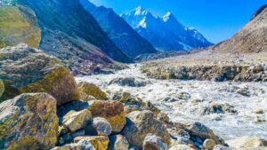
From Gangotri till Bay of Bengal, I saw a massive civilizational crisis emerging. If that is not addressed, we will –all–be in deep trouble. Ganga is the largest river of India and its plain is the most fertile land where farmers have flourished and millions of people depending on water, gained life and livelihood. The bio diversity of the river Ganga remains unparalleled.
Chipko Movement
In Uttarakhand, the Ganga and its tributaries face threat from various hydropower projects because they snatch the beauty of the river, control its water and impact the rich bio-diversity of the river.
A travel to Niti Valley and Lata and Raini villages, the epicenters of the Chipko movement, gave me the idea of what is wrong with those who romanticise a movement without understanding it’s nature. The Chipko movement was the cry of the native communities for their access to forest produce which they used to enjoy prior to the Indo-China war 1962 when people had access to the Tibetan market and vice versa. There was a huge market for domestic products, forest produce etc. A large number of villagers got dislocated and all the passes to Tibet were closed. The other side of the story is that government continued with the British policy of auctioning the forests. So every year, the Symonds company would obtain the forest produce, chop the trees mercilessly and take them out of the state. Gaura Devi and her Saathis protested against this in Raini and threw the contractors out. This was welcomed by all in Uttarakhand and the movement gained prominence. H.N Bahuguna, the chief minister, called some of the ‘activists’, mostly the Brahmanical elite, to Lucknow for a conversation. The auctioning to ‘privates’ was stopped by a new entity (boss) was created which was the ‘Uttar Pradesh Van Nigam’. This made the lives of the people even more miserable. While many people got name and fame internationally, the native (indigenous) people fighting had to resort to ‘Chheeno Jhapto’ movement to gain the access to forest. H N Bahuguna therefore emerged as the biggest villain of the piece who actually looked down upon this movement and tried to sabotage it.
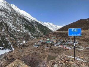
The problem with the intellectuals and their devotees in the media is that they ignored that the essence of the movement that was essentially led by Adivasis-janjati people. The history of the Chipko movement is that of those people, the Bhutiyas and others but their issues and role were conspicuously obliterated from the popular discourse. The movement was superficially romanticised as a ‘protection of trees and ‘environment’. World over, it is the indigenous communities who are dependant on forests and it is they who nurture it. No community would ever nurture mountains and rivers without using the resources. This needs to be understood. That the relationship between native communities and nature is their interdependence; this issue was grossly ignored and underestimated by the environmental elite.

Ganga and its various tributaries shine through Uttarakhand. The confluences of different rivers are unparalleled and stunning. Sadly however this will all disappear once different barrages and dams that are proposed actually start functioning. There was a beautiful Sangam of Bhilangana with Bhagirathi at Tehri which is not visible now. There is a beautiful Sangam of river Gori with Kali at Joljibi in Pithoragarh. If the Pancheswar dams comes through, then some of these beautiful places and confluences will disappear. The Sangam of Rupin and Supin river at Netwar in Uttarakhand which start the journey of Tons is supremely beautiful but a dam near the confluence is bound to finish them off. Nobody can deny the importance of energy but we also need to think that the Himalayas and its rivers are not merely our ‘resource’ but also our heritage, our identity particularly for the people living in these regions. So, my simple point to the power elite is stop destroying our identity. A destruction of the Himalayas will bring unprecedented crisis to Gangetic plains in India and so, we must not do anything that escalates the crisis we already facing.
The crisis in the Gangetic plains of Uttar Pradesh
The Gangetic plains of Uttar Pradesh will suffer in future with acute desertification. The Ganga loses its shine once it enters Balawali, Bijnor district. Travel to this region and onward during the summer, and you will realise how the Ganga water has drastically reduced and agricultural land and green pastures have been converted into a desert. Already. Water at Garhmukteshwar remain merely for the rituals and the pollution is increasing exponentially. By the time, it reaches Kannauj and has its first confluence with Ramganga, you can walk through the river Ramganga. Reaching the confluence has been difficult because of changing embankment of the river. A local farmer told me at the confluence that it is not the ‘kheti (farming) but ‘reti’ (sand mining) which is rampant and ‘source’ of earning for even the farmers. This reflects the sad state of the crisis.
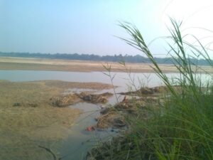
A few kilometers onwards, we are at historic place Bithoor which is now more known as a ‘religious’ place and to ensure that magnetism of religion. Suddenly, you really feel wonderful to see ‘water’ in the river. A couple of boats are visible and again we see the beauty of the river Ganga but our fear are confirmed. About seven kilometers from Bithoor is the Ganga Barrage on the Kanpur Unnao border. While there is enough water to quench your religious thirst at Bithoor, at Kanpur the river looks dry with huge sand beds on both banks. You won’t be able to recognise the river from the original embankments. Moreover, Kanpur which is called the Manchester of the East, is actually, contributing a huge quantity of ‘sewage’ water to Ganga making it look like the Sewage tributary of the Ganga. The river stinks on the ghats. It is very disturbing to see that ‘Ghats’ that have been constructed with money from the ‘Namami Gange’ project but no efforts are visible to improve the plight of the holy river. All it reflects that we want to worship the river from a nice built-up place of concrete but don’t really care about the existential crisis that the river is facing.
The patch between Allahabad and Varanasi via Vindhyanchal is beautiful and water less contaminated perhaps because of the Yamuna which is bigger in Allahabad and carries more water from Chambal in it which is definitely an unpolluted river. At Varanasi, however, we see the devastating pollution in the river. We are told that two ‘rivers’ flow into Ganga in Varanasi, the Assi Ganga and Varuna. A visit to the ‘confluence’ of them only reveals the pathetic hypocrisy of those who call them ‘rivers. They have been turned into absolute sewage ‘rivers’, and further pollute the Ganga.
Ganga at Varanasi
At Varanasi the Mahaarti has been commercialised. It has become a ‘light and sound show’ with no real spiritual power which it used to emit once upon a time. Big moneyed people use the trawlers and cruise to watch the spectacle while the normal, common humans have to pay huge sum to watch it from the back. It was definitely a sad scenario.
Between Varanasi to the Gomti Ganga Sangam is again a pathetic sight. There is no water in the Gomti and it is much polluted river. There are lots of birds on the island zones in the Sangam. Ganga’s entry into Bihar is via Buxar and just a few kilometers before the city is Chausa, a historic town where Sher Shah Suri’s forces had defeated Humanyun. The so-called memorial is nothing but a ‘selfie park’. All memorial and historical places are carefully being converted into amusement parks everywhere and mythological characters are being re-created as historical figures and events. Again, the Karmnasha-Ganga confluence shows the terrible state of agriculture in the region. I was there during the deadly heat of June and the Karmnasha looked like a dry stream flowing into Ganga. Agricultural land showed sign of ‘cracks’ even when we would see numerous birds chirping near the confluence. Sewage continues to flow into the river in Buxar too.

Massive sand mining in Bihar
But the biggest challenge, I saw on our rivers was at a historic place called Chirand in Saran district where the Ghadhra and Son[1] rivers flow into the Ganga. The confluence zone has shifted a few kilometers again. From Revelganj to Chirand, on the National High way, a huge smoke of dust welcomes you apart from huge lane of big trucks used for carrying Sand. On the banks of river Ghaghara, which local call Saryu, you can see hundreds of cargo streamers used for carrying sand from the river. Any person who is not habitual of staying in these zones, would just collapse as breathing become impossible. The Red Sand from river Son is the most popular. It is also a fact that Sand mafia has political protection. It is time for sensitization of people as well as stricter environmental norms imposed otherwise this region too wait for a catastrophe. Similar conditions can be seen around Hariharpur Sonpur area where Ganga and Narayani Gandaki conflate. Sonepur was famous for the cattle fair but that is a thing of past now. It is merely a fair which is more as a recreational ‘time pass’ for the locals and others who visit the famous shrine at Hariharpur.
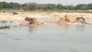
The river Ganga in Patna looks polluted. Patna itself is a polluted city. From there until Munger, we can see the Ganga splitting at various places and huge sandy river beds everywhere. The summer in these regions are extremely difficult with massive dust in the air. Most of the agricultural land is turning barren. Water level in the river is reducing drastically resulting in the extension of its breadth and creation of the sandy patches or islands in between. You can see huge bridges across Ganga but the river looks tiny. The only time it does look like a river is in the monsoon season. Mokama, Begusarai and Khagaria present an abysmal picture but the biggest shock was at Kosi Ganga Sangam which is difficult to reach due to the river bed turning sandy. To reach to the area is difficult. On a normal winter or summer day, the water at the confluence is extremely low and the river looks dirty too. Again, the breadth of the river increases. However, from Manihari in Katihar to Sahebganj, a trip on a cargo Ship is a worthwhile memory to stack away though it is difficult to cruise because of low water levels. But this will work till the bridge connecting Sahebganj and Manihari is completed.
Historical Rajmahal
However, the most fascinating part of the river Ganga (Ganges) in Bihar is in South Bihar. From Munger –which itself is a historical place—the old fort area is totally encroached upon and you will see no effort to preserve the historical architecture and buildings. The river from Munger to Bhagalpur and Kahalganon is phenomenal. It is a breathless treat to watch. It looks less polluted and is called ‘Uttar Vahini’ at Sultanganj where the historical Ajgaibinath temple is located. Bhagalpur is an extremely important location where enough evidence exits of our Buddhist, Adivasi and Jain past. There are historical places. The most beautiful region is Kahalgaon and Vikramshila. It has been reported that the entire area from Sultanganj to Kahalgaon, has been declared by the Bihar government as a ‘Dolphine Sanctury’. The fisherfolks are protesting against it as they lose their right to fishing. The Ganga Mukti Abhiyan started from this place fighting against the Zamindari on water and finally Lalu Prasad Yadav as chief minister of Bihar ended that cruel system imposed during the British period that looted the fisher communities of the region but the lives of the fish workers are not safe. Zamindari has gone but Rangdari has started. People still live in fear.
Sahebganj is the only Ganga district in Jharkhand. The Ganga here as a massive presence between Manihari to Sahebganj. There is an international port and a domestic one, possibly one that is under-utilised. The water level is still not that much which can ensure an easy passage. Secondly, the Ganga splits more in Jharkhand. Various streams split up and join again. The most important place of Ganga journey in Jharkhand is Raj Mahal, a very historical place, former capital of undivided Bengal under the Mughal King Akbar era. Raja Man Singh was made the Viceroy of Bengal and it is he who established Rajmahal as the capital of the state. It still has few landmarks like Jami Mosque, Baradari and many other places which still need deep care as they remind of our rich historical legacies.
Between Raj Mahal and Farakka, the Gumani river rising from the Raj Mahal hills ultimately merges with the Ganga and then moves towards Farakka. The link road between Rajmahal and Farakka is in extremely bad shape in the last 10 kilometers perhaps because it is the area of coal mining and thermal power plant. Again, the air is filled with dust and smoke most of the time in nearly 10 kilometers area. One can just imagine the lives of people during the summers here.
The one point on which the fisherfolk from three states, Uttar Pradesh, Bihar, Jharkhand unit is on the issue of Farakka Barrage. They want this barrage de-commissioned as it has damaged the fish diversity in the river above Farakka. Hilsa is not available to fisherfolk in UP, Bihar and Jharkhand. After Farakka, fisherfolk claim that they do manage to harvest the fish but due to the closure of gates at the barrage, Hilsa and other fish can’t move back. Many farmers too reflected that due to the existence of a barrage, a large part of land in Jharkhand and Bengal face flooding in monsoon. The impact of Monsoon floods is tremendous in Bihar and Bengal and governments have so far not been able to reach to any particular conclusion or solution so that human lives or agricultural land is not lost. Every year, the soil erosion has already engulfed thousands of acres of land and made people landless. It is time for a serious think over –and concerted response to–these issues and protect our communities, farmers, fish workers and others living nearby the river.
Ganga in Bengal: Rise of Bhagirathi
The journey of the mighty Ganges (Ganga) in Bengal is extremely important to understand the issue of climate change. The split in the rivers become the norm. Right from Nimtitta town, the Ganges becomes wider and splits into two parts. The river flows towards Bangladesh and is known as Padma there while the second part of the river again splits at Giria and is known as Bhagirathi which then travels to different districts from Murshidabad, Plassey, Nabadweep where again Jalangi meet it and the new river is now known as the Hooghly. The interesting part is that there are towns on both sides of the Hooghly. There is history. Nabadweep is the birth place of Chaitnya Mahaprabhu. After passing through many places the Hooghly ultimately flows into Bay of Bengal in the Sundarban region. The place where it merges into the sea is known as Ganga Sagar but Sagar Dweep itself has numerous issues of climate crisis. Many villages have disappeared and many might disappear in future as the water level of the sea is rising regularly.
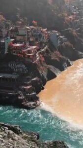
To conclude, I would say, preserving Ganga is extremely important for the health of India as it emerges from Himalayas and finally flows into the Bay of Bengal near the Sundarban. Both the Himalayas and Sundarban are world heritage sites. The impact of climate change is acutely visible in both these places. The question is whether the so-called climate change is a natural process or a human-made disaster. The number of commercial activities in the Himalayas as well as in Sundarban are bound to impact all of us.
We need to think out of the box but certainly not to convert the entire issue of Ganga and climate change to one merely concerning ‘experts. It is time, we engage and involve the local communities, fishermen, farmers and other native communities who are inter-dependant on the river and its surroundings as without their active participation in any debate or decision-making processes, we won’t be able to achieve anything meaningful.
‘Save the Ganga’ slogan means protecting and preserving Himalayas and Sundarbans apart from all the big and small rivers and large riverine area that makes up the mighty Ganga.
(This is the text of the talk delivered at Jawahar Bhawan, New Delhi, on November 18, 2024, was organised by Rajiv Gandhi Institute for Contemporary Studies)
[1] Ghaghra and Son are the tributaries of river Ganga. Ghaghara is a 1080 km long river that originates from Mapchachungo Glacier in Tibet. It flows through Tibet, Nepal, and India where it joins river Ganga near Chhapra, Bihar.
Related:
VECL consistently flouting environmental laws: Paryavaran Suraksha Samiti
Vapi Industries Association wants Gujarat Pollution Board to relax environmental clearance norms
