
“I have spent my life battling erosions and subsequent hunting for land to set up a house. I have spent my life in this struggle and till now I had a way to find refuge in the village. But there will be nothing left in the village for future generation”, Ali said, explaining the extent of erosion affecting the village. He was speaking to Maktoob media recently.
A remote village, about 105 km from Guwahati, Rasulpur was previously heaven for traditional cultivation of paddy, jute, blackgram, peanuts as well as perishable vegetables such as brinjal, cauliflower, cabbage, okra, etc. with its vast expanse. Over past decades however the village shrunk to “a proportion from where it will vanish from the map”. Termed a large village with almost 8000 bighas of land fertile for cultivation today it has a merely 50 bighas (16.5 acres) of land remain here”
Truth is, as Sabrangindia has previously analysed and reported, 51 percent of the total land of Assam is covered by Forest area, 15 percent is under water. Thus, only 35 percent of the total geographical area is only open for either agricultural use or for homestead use as per Directorate of Economic and Statistics, Government of Assam. Taking this into account, the Water Resources Minister’s submission before the state legislature in 2021 warned us of the huge topographical, climatic and migration pattern changes that have been impacted by river erosion. This remains key to understanding geo-politics here.
Who are the worst affected people?
Who are the people affected by the large-scale erosion? It is Muslims, especially the East Bengal origin Muslims, who were settled in Assam before Independence and Partition, due to British policy of:
a) grow more food,
b) grow cash crops,
c) gather more land revenue.
They were settled in the riverside areas (also known as Char lands) of Assam in between 1901 to 1946 and earlier, and are the worst affected by this cycle of perpetual erosion.
Incentives like issuing free family tickets of trains, so that they come to Assam and settle here. They were also allotted certain plots of vacant etc were offered by the British to Bengali Muslim cultivators; they were exempt from paying land taxes for a certain period. But, this was a double-edged sword: due to the line-system, also put in place by the British, these Muslims were confined and deprived of free movement, not allowed to cross this imaginary line. These imaginary lines were carved only to prevent them from moving out of the riverine area.
Almost, all the land of these nce had been washed away by repeated flood and erosion of land in the state since 1967. It has compelled them to migrate to the plains for a livelihood, fueling phobias of land grabbing and Bangladeshi intrusion.
After Muslims, a large number of Bengali Hindu people too, who have also migrated to the state since the early part of the 20th century, and even after partition of India in 1947, had to change their habitation as they failed to co-exist with the river. Apart from Bengali Muslims and Bengali Hindus, several thousands of Adivasis (tribals) from various upper Assam districts too are affected by this erosion and even a section of Scheduled Caste people, especially the fishing community of non-Muslims are similarly affected by this large-scale river erosion.
When Muslims were uprooted from their land due to erosion, they were tagged as land grabbers and Bangladeshi infiltrators. In the case of non-Muslims, who were forced to migrate due to land erosion, they became tools for communal propaganda.
So Ziad Ali and Nurul Islam from Rasulpur are only a few of the victims.
67-year-old Islam, a resourceful person in the area recalls with pain, “Once people from our village were self-sustaining. But with all the land gone into the river, our younger generation is becoming migrant labourers in other states as there is no hope left here.” (1 acre= 3.025 bighas)
Rasulpur has diminished to a shadow of itself over decades. “No physical forms of our struggles and communal rejoicing moments that we had while harvesting, celebrating festivities or collaboration in ceremonies will be left” as Nurul pointed to the harmonious past days. No politician or official had visited the village during this year’s erosion reflecting “their indifference” to the issue.
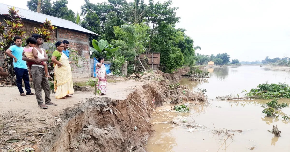
The latest round of erosion of Rasulpur village by Beki River’s torrent started in May with the unseasonal rains and floods and has been continuing in the weeks since. Kadong Bazar used to be far away from Rasulpur but due to the continuous erosion, the gap between the market and the char narrowed down to only around 500 metres. In the latest wave of erosion, around 40 households were washed away at the village where a total of 102 families were residing according to Population Census 2011.
At present, some of the eroded families have taken shelter near the roadside and some have dispersed to other areas in temporary settlements.Apart from losing the only livelihood option of cultivation, the families are also in distress as there is no land left for dispersed to build a house. “Earlier when erosion caused displacement, people who had some land away from the river offered fellow villagers to build a house and restart their life. Now almost the entire village is going down, so there is no land to offer. Where do we build a house now?”, asked 45-year-old Bahar Uddin.
Erosion by Beki
The Beki river basin, streamed by the Himalayan glaciers from Bhutan, originates from Mathanguri in Manas reserve forest and flows in Assam through Chirang and Barpeta districts (north-western districts of Assam) before merging with the Brahmaputra near Balajan area of the later district.
Flowing 85 km from Bhutan and draining around 26,243 square kilometres, Beki River causes a high magnitude of flood and erosion, usually due to heavy rainfall in the upper reaches of the Himalayas and sometimes due to the release of excess water from Kurissu dam in Bhutan.
According to a detailed project report by the Water Resource Department of Assam, massive floods and erosions devastated the district in 2004, 2007, 2009, 2015 and 2016 making hundreds of families internally displaced peoples. Since then the department has prepared a project worth more than Rs 400 crore to contain the erosion of Beki River as Assam government’s data tabled in the assembly.
In order to rehabilitate the erosion-affected homeless and landless people in Assam, the state government in its special scheme in 2021 to provide rehabilitation to erosion-affected families set up a mechanism for providing the relief measures in monetary value. It mentions that the erosion-affected families need to submit an application to the concerned circle officer for verification and the circle officer would verify the application from land records as well as through field verification by Lot Mandal. However, due to illiteracy and unawareness, the villagers from the Barpeta district obtained neither an erosion-affected person certificate nor a rehabilitation package.
It is crucial that these important documents and benefits for the erosion-affected families, especially for char dwellers, are made available to affected families. Erosion certificates or government benefits provide a legal document for the people who are to be labelled as illegal immigrants or illegal encroachers. In both situations, the documents can prove their previous habitat and fend off the tags of illegal settlers or Bangladeshi migrants.
Related:
EXCLUSIVE! River erosion washes away over 35 percent of Assam’s agricultural land